

After a beautiful night at anchor near Little River Inlet, we got underway on the morning of April 1st, headed to North Carolina. Our ultimate destination for the day was Southport, NC, but we wanted to make a quick stop along the way in Holden Beach because our five-year-old grandson, Holden, was named in honor of the many fond memories that our daughter and son-in-law have of trips to Holden Beach with his family. We tied up at the empty city dock, which was located right on the ICW, and called the posted number for City Hall for permission for a very brief stay. We made the short walk to the beach, then took some photos in front of the “Holden Beach” water tower to share with our Holden. When we returned to the boat, George discovered that we had no water pressure. It worked off and on when we played with the fuse, but the pump was hot and intermittently shut down. Another item was added to the Assisted Living “to do” list.


We had planned to dock in Southport at Provision Company restaurant (like many waterfront restaurants along the Loop, free to dock if you have a meal at the restaurant). When we arrived, however, their slips looked way too short and way too shallow. Even if we pulled in bow first (to keep some distance between our props and the shallower water near land), our bow would have been sitting on sand and the back half of the boat would have been sticking out into the channel. We later spoke to the local AGLCA Harbor Host, who had recommended the dockage, and he told us he had indeed docked his own 40’ boat there many times, but yes, the back end had hung out a bit.
We decide to go with Plan B: anchor in Dutchman Creek. But like the early Israelites wandering in the desert, we could not find a home. Dutchman Creek was way too narrow and way too shallow; even George was nervous and he spun the boat around and gingerly picked our way back out carefully keeping to the path we had followed on the way in. We briefly considered another anchorage, Dutchman Creek Park, but couldn’t get any confirmed intel on it, so to put an end to our wandering misery, we made a reservation at Deep Point Marina, which was located on the east side of Southport.

When we got tied up at Deep Point Marina, we found that that the freshwater pump had overheated again, so finding a replacement pump became our number one priority (we were pretty partial to having running water on the boat). We quickly learned that the Jabsco pump we have was no longer being made (of course). George located a Jabsco pump that was ridiculously expensive, but it was at a West Marine in Wilmington, NC, over 30 miles away, a tad beyond the range of even our fully functioning electric bikes. After much research, and several phone calls, we found a washdown pump that was similar to the Jabsco freshwater pump (sadly 4gpm instead of 5gpm), and it had the same waterline connections, which was key, since George preferred to not have to replumb the boat. Unfortunately, the alternative washdown pump had a different mount, but George figured he could modify the mount to make it work with all the drills, saws and other tools we lug around on this adventure. He biked over to the local NAPA Auto parts store and handed over his wallet for a pump we hoped would work.
After an intensive yoga and gymnastics session in the small compartment under our galley floor, George wrestled off the old pump, and like a little Dutch boy, held his finger in the dike to try to stem the flow of the water draining from the pipes since Ranger Tug did not think to include in its design a shut off valve at the pump (Gosh, who knew a freshwater pump on a boat would need to be periodically replaced? Just every single person that has ever owned a boat with running water, that is who. C’mon Ranger Tug, seriously?). While George endeavored with limited success to keep from flooding the lower compartment, Chris carved down an old wine cork to fit into the opening. It worked marginally better than George’s finger but did allow him to move on to the task of drilling new holes to accommodate the different mount of the new pump. After securing the mount, and drying out the compartment, George made all the new electrical connections, and we were back in business. We had a celebratory margarita on Assisted Living, then biked into town for dinner at Provision Company.


The next morning, Chris was tied on a business matter, so George went solo on the ferry to Bald Head Island. George was thoroughly charmed by this unique little island. No passenger cars are allowed; instead, everyone gets around by golf cart. The well-spaced homes were generally obscured by scrub oaks and lush landscaping, and the entire community was quiet and serene. He climbed up Old Baldy, the oldest and one of the most iconic lighthouses in North Carolina, visited the lighthouse museum and caretaker’s cottage, then explored the beach with its large dunes.


We reunited on the boat for lunch, then George set to work on planning our itinerary for the next 7 to 10 days. There was a strong front coming through that would blow for days at over 20 miles per hour, and then a second front predicted for two days after that. He scoped out marinas along the route where we could sit out the big blows and came up with a plan.
By late afternoon we were both ready to get off the boat for a bit, so we rode our bikes into Southport proper and meandered around town. George toured the NC Maritime Museum at Southport, then we stopped at Oliver’s on Cape Fear for some refreshment. We rode further along the waterfront and spied Robert and Kay Creech and another looper couple on the Creech’s porch enjoying “Porch Time.” Robert and Kay, now in their late seventies or early eighties, are looper legends. They are Gold Loopers and incredible Harbor Hosts for the AGLCA and a time honored looper tradition is to sit with them and have a drink on their porch when passing through their hometown of Southport. The experience lived up to its hype. They are gracious hosts who shared a wealth of knowledge. We finished off the evening with dinner along the waterfront at Fishy Fishy Cafe and then biked back to the boat in the dark. Thankfully, our bikes were equipped with good headlights.


The next morning, we were off the dock early because we needed to arrive at our next destination at high tide. We carefully timed our departure from the narrow harbor channel to avoid the outgoing and incoming ferries, all big and moving very fast. We headed up the Cape Fear River, then just before Snow’s Cut ducked into the marina at Carolina Beach State Park. The entrance was shoaled, as reported, but we arrived close to high tide and never saw less than three feet under our props. (For loopers headed this way, the marina is a real bargain; only $52 for our 43’ boat, but keep in mind that there is likely only room for one big boat in the marina, so you will need to plan ahead if you want the spot.)

We had chosen to visit Caroline Beach State Park because it is the only place in the world where you can find Venus Flytraps growing in the wild. It is also home to numerous other carnivorous plants, each more fascinating and creepier than the next. With some detailed guidance from the dock manager that checked us in at the marina, we knew where to look and what to look for along the many park trails. We scored our first success spotting a Venus Flytrap beside the wetlands trail boardwalks in the island’s interior, and we counted it as a major achievement since the delicate traps are only about ¼” on average. I told George that in the cartoons of my youth, the traps were always so much bigger. Once we spotted the first one and adjusted our expectations of what to look for, we saw them all along the trail. We also saw many carnivorous Pitcher Plants, which are droopy tube looking plants that attract and digest their prey with nectar. We eventually made our way to the park’s visitor’s center, where we found another good trove of Flytraps and Pitcher Plants, and walked through a rather eerie exhibit about carnivorous plants of all kinds.
From the park, we were able to link up with the Carolina Beach Greenway, an extensive walking and biking path leading to the beach and then back to the Carolina Beach Boardwalk which runs along the beachfront commercial tourist attractions. We stopped before reaching the boardwalk to enjoy breakfast (for lunch) at a local diner. After brunch, we walked our bikes along the Beach Boardwalk and stopped to relax at one of the many oversized porch swings that were installed overlooking the beach.


The next morning, April 4th, we waited for the tide to come in, then threw off the dock lines, rotated in the tight fairway, and headed out the channel. We never saw less than 4’ under our props. We turned right through Snow’s Cut, went under a bridge, then continued on the ICW into the NE Cape Fear River. As we approached the Masonboro Inlet, the water changed to a beautiful light green, the first pretty water we had seen since leaving Palm Beach, Florida. There was a veritable parade of boats in the ICW since it was Easter Weekend and was sunny and warm with bright blue skies. It was kind of like boating in Panama City on the Fourth of July – a ton of boaters who take their boats out once a year packed with family and friends. We constantly zigzagged to avoid small boats drifting and slowly motoring aimlessly in the middle of the narrow ICW. The biggest challenge was trying to anticipate what they might do next since many of them had no clear direction or destination and occasionally went from 2 to 15mph without warning.

We had gotten spoiled by the fewer low bridges as we moved north and had failed to do our homework about the upcoming Wrightsville Beach bridge. At 11:15 we approached and learned that the next opening would not be until 12:00. With forty-five minutes to kill, and surrounded by wandering looky-loo boats, we pulled over to the Bluewater Waterfront Grille restaurant dock located adjacent to the bridge. Chris hopped out to put in a quick order for some takeout to justify our presence at the dock, while George inexplicably decided that it would be a good time to jump in the water to inspect our props and hull. He somehow managed not to be swept away by the strong current and was back onboard and dry before Chris returned to the boat at 11:40. At 11:50 we released our dock lines and nudged our way back into the thick of the boat traffic waiting for the double bascule bridge opening. Chris stood on the stern of the boat and stared down all the idiots in small boats that came up on us too fast or too close. When Chris joined George at the helm after passing through the bridge, George surprised her by reporting that our props and hull looked to be in excellent shape, and it was then that she realized that not all the idiots that day were on other boats.
Having now been reminded of the importance of timing our arrival to match scheduled bridge openings, we looked ahead and saw another low bridge five miles ahead. On the VHF radio we heard that the bridge would be opening at 12:30 for a waiting sailboat, so we did a speed run and ensured that we were there to pass through at the same time. Further along, we passed under the Surf City Bridge, and noticed that with our distance from the inlet the water was no longer a pretty green, but was instead the standard chocolate brown of the ICW.

Fifty-four miles after departing Carolina Beach State Park, we pulled off the ICW into the anchorage at the southwest end of Camp Lejune, Mile Hammock Bay. There were two sailboats and another trawler already anchored, so we picked a spot off to the side and dropped anchor. Shortly thereafter, Catalyst II (Lisa and Kirk) and two other sailboats arrived. Within thirty minutes it was clear that we were dragging, so we pulled up and reset our anchor, and this time it seemed like we got a good bite. At least there was a decent crowd to be entertained by our anchoring trials and tribulations (a reminder that either you are watching the show, or you ARE the show).
We grilled some nice steaks for dinner, then considered our upcoming plans for our next destination, Beaufort (“Bow-fort”), North Carolina, forty-four miles away. The wind was predicted the next day to pipe up by noon to 20-30 knots, which would make crossing Bogue Sound uncomfortable and docking in Beaufort difficult. One option to consider was to stay put another day and depart the following morning after the front had pushed through and winds shifted to the north. We opted to stay put, and the wisdom of that decision was confirmed the next day by Catalyst II who left the anchorage early and reported back that conditions were miserable crossing Bogue Sound with a long, unprotected fetch from the south. All the other boats had also left the anchorage, but by mid-morning when the wind started to pick up again we were joined in the anchorage by Antonia with Neill and Joannie, whom we had met the week prior.

We experimented that morning with a small masthead sail that our daughter-in-law Katie had made for us at George’s request to see if the sail would reduce the large arc of our swing at anchor, and he felt that it did reduce our swing by about 15% (from a 75 degree swing to one more like 60 degrees). We took the sail down before the super big blow came in, and around noon, as predicted, wind increased to a sustained 20 knots, with strong gusts over 30 knots. At about 15:00 we notice that we appeared to be moving closer to Antonia, and sure enough we were dragging, again! The anchor alarm sounded shortly after we noticed.
While Chris powered the boat into the wind, George struggled to release the anchor bridle since it was under so much tension, then we turned to the tedious task of pulling the anchor chain in with a windlass gypsy that was slipping and was under incredible strain from the wind. When we reset, it still didn’t hold (Antonia reported that we may have been moving forward when we dropped the anchor – George was apparently overcompensating at the helm for the wind). A literal boatload of mud came up with the anchor when we pulled up again to reset, and George and the entire bow of the boat was drenched by spray as he tried to hose off the mess. Boy, this was fun. On our next try, we successfully set a good anchor, but we were careful to monitor our location for the rest of the day and night both visually based on location and with two separate anchor alarms. We have since seen lots of chatter on the AGLCA Facebook page about many boats dragging anchor at this anchorage. It has generally and historically been reported to be a good anchorage, so it must have had something to do with the relentless strong fronts.
The wind gradually abated (well, some) but was replaced by a deluge of rain and fierce lightening. Our anchor held, but the anchor chain was so tight it was practically horizontal, so when the boat swung to starboard the anchor chain caught on the port auxiliary anchor hanging from the bow with a loud and violent “twangggg.” We suited up in rain gear and climbed onto the bow to release the auxiliary anchor enough to pull it over the front of the bow out of harm’s way.
After consulting with Neill, George decided that part of our problem was our boat’s extreme swing (almost 80 to 90 degree of swing in the high winds), so he put the masthead sail back up, and it seemed to reduce the swing some, but not as much as he had hoped. When the rain started to slow, the wind eased, but we knew that the forecast was for more extreme wind starting around midnight, so we couldn’t relax. Not surprisingly, it was a miserable night. George was up and down all night and out on the bow trying to rig something that would reduce the noise from the anchor chain and the violent jerks as we reached the extreme end of each point in the arc. The good news is that every time we checked, the anchor alarms showed a nice smooth arc equidistance from the anchor, kind of like a nice little smiley face. We may have been miserable, but our anchor was holding.
George was up at 0630 to take down the masthead sail and dismantle the various anchor chain “fixes.” We started pulling up the anchor chain just before 07:00, but it took nearly thirty minutes to get it up because it had been so far buried in the mud that we had to constantly stop to wash off the mud so we wouldn’t clog up the anchor locker with all the muck. The process of bringing up the anchor was further complicated by the fact that the anchor windlass gypsy was worn out and the chain kept skipping. We will pick up the replacement gypsy we have ordered when we arrive in Annapolis, and until then, pulling the anchor will be a frustrating chore.
Nearby, the Onslow Bascule Bridge was on a strict schedule. It would only open at 0800 and then would be closed until noon to accommodate construction, so it was imperative that we make the 0800 opening. We finally got the anchor cleaned and stowed and made the 0800 opening without any other issues. As we passed Camp Lejune we were impressed with the number of warnings about the possibility of unexploded ordinances. We passed Hammocks Beach State Park, and then turned easterly into Bogue Sound, with a gentle 10 knot north wind on our nose.


We pulled into our slip at Town Creek Marina in Beaufort, NC shortly before 14:00, leaving ourselves plenty of time to do the short bike ride into town. To get the lay of the land, we had booked a golf cart tour with Barefoot Wade, and sure enough, Wade was barefoot when he met us in town to pick us up for the tour. Wade drove us through beautiful residential streets, pointing out and sharing the history of homes dating from the mid to late 1700s and early 1800s. He walked us through the Old Burying Ground and shared many interesting stories and tidbits (he also does cemetery tours, so we kind of got a two-for-one). He showed us the historic home, Hammock House, where Blackbeard often stayed on his many visits to Beaufort. There was some sort of handshake deal that the pirates would refrain from stealing and pillaging Beaufort in exchange for being allowed to use the city as their land based safe haven.


While on the tour, we received a call from home and learned that the extraordinarily high water bills for our house were likely due to a waterline leak in the concrete foundation somewhere underneath the kitchen and an adjoining bathroom. I guess our day could have been worse; at least we didn’t hit an unexploded ordinance when we passed Camp LeJune.
After the excellent golf cart tour, we walked the length of Beaufort’s waterfront boardwalk and stopped for a drink on the patio at Moonrakers, overlooking Taylor Creek. Dinner was at Mezcalito Beaufort, and the portions were so generous that the leftovers we brought back to the boat provided several more dinners and lunches. Back at the boat we started a movie on Netflix, but Chris slept through everything except the opening credits.

We spent the next morning working on the boat; Chris on some pressing business matters and George on our upcoming itinerary, and a plan to address the waterline leak buried deep in the concrete foundation of our Panama City home. That afternoon, with high tide approaching, we launched our dinghy so we could explore the Rachel Carson Reserve. We were fortunate that the boat in the slip next to us was small enough for our dinghy to just barely fit in the space between the boats. The Rachel Carson Reserve is an undeveloped island across from Beaufort that is the home to a herd of wild horses. The weather was cloudy, cold and windy, so we bundled up in our offshore foul weather gear. We motored across Town Creek and wound our way around the west end of Beaufort, then headed east two miles down Taylor Creek. Along the way, we spotted a handful of feral horses grazing near the water. We beached the dinghy on the far end of Carrot Island, and walked the nature trails, but did not come upon any horses, although there was ample evidence that they had been there recently (had to take care where we stepped). As we headed back the way we came, we again saw several beautiful horses along the shoreline. We crossed to the opposite side of Taylor Creek and admired the beautiful homes along the waterfront, many of which were historic.

When we returned to the marina, two slips over we found our friends Ed and Alison who had just arrived on Love Me Fender. They were headed into town for dinner, but we had already prepped for dinner on the boat, so agreed to catch up when they returned. After dinner, Ed and Alison joined us on Assisted Living and we made plans to explore the town of Beaufort together the next day.

The next morning, Ed had to see a man about a boat haul out due to an unfortunate grounding they had experienced on the way to Beaufort. George and Chris went ahead by bike into Beaufort with a plan to meet up with Ed and Alison in town for lunch and some museums. There was wicked 30 knot north wind blowing and it was hard to keep upright on the bikes. We made it into the shelter of historic downtown Beaufort and made a stop at the Visitor’s Center to pick up some brochures and gather information. Armed with a detailed brochure with stories of those buried in the Old Burying Ground, we walk to the cemetery and read our way through a self-guided tour. One of the more interesting stories was the story of the Rum Barrel Girl. A young girl who had been born in England and brought to Beaufort as an infant always wanted to see the country of her birth. When she was about ten years old, her father finally agreed to let her accompany him on business trip to England and he promised his wife that he would return their daughter safely to Beaufort. On the trip over, the little girl became ill and passed away. It was customary at the time for those who perish at sea to be buried at sea, but the father could not bear the thought of not returning the girl to her mother in Beaufort. From the captain of the ship, he purchased a barrel of rum where the girl was preserved until the ship returned to Beaufort. The little girl was buried in the Old Burying Ground in Beaufort, and her grave is covered with trinkets and memorials left by those who visit the cemetery.
After the cemetery tour, we walked a few blocks to meet Ed and Alison at Beaufort Grocery Company restaurant but found that it was closed (shocker of all shockers – you can’t trust all the information you find on the internet). We ended up at Black Sheep for some excellent pizza and salads, so considered the day salvaged. We spent a few hours going through the North Carolina Maritime Museum, and one of our favorite parts was a shell exhibit explained by one of the Museum’s “mature” volunteers. George remarked that she made the shells of Beaufort “come alive” (she really was something). We had to leave the museum before we were ready because we were booked for an afternoon tour at the Beaufort Historic Site.


The Beaufort Historic Site includes six historic structures from the 18th and 19th century coastal Carolina. A volunteer docent lead us through a 1778 colonial home (simple and tiny, but formerly occupied by the head schoolmaster, his wife, and five(!) children); the 1796 Carteret County Courthouse (the accused, all witnesses and observers had to stand behind a wooden rail that divided the room; only the judges and the lawyers could proceed beyond the rail, leading to our phrase, “admitted to the bar”); the John C. Mason House, circa1825, a classic Federal style house on its original site, and an excellent example of Bahamian architecture which is prevalent in Beaufort (breezy porches on every story); The Josiah Bell House (c. 1825), a wonderful example of Victorian architecture and décor; the Old Jail (c. 1829) which was in use until 1954 (crime did NOT pay in Beaufort); and last, the favorite of our two retired physicians (George and Ed), the Apothecary & Doctor’s Office (c. 1859) with a priceless collection of medicinal and pharmaceutical artifacts.


We tried to go back to the Maritime Museum, but it was closed by the time we returned, so we walked across the street for some refreshments at Finz Grill, then went to a historic Beaufort restaurant, Clawson’s, for dinner. It was a full day, but a lot of fun.

The next morning, Chris had to work, but George, Ed and Alison borrowed the marina’s courtesy car, and went to Fort Mason, which is situated at the mouth of the Beaufort Inlet. The fort had a floodable moat between its inner and outer wall fortifications. There were cannons from both the Civil War and from World War II. Its brick construction was similar to most of the Civil War forts we have visited over the past few months, and like all the forts that were part of our coast defense system, it became obsolete with the advent of more modern warfare—the rifle cannon.


After a quick stop to reprovision on the way home, we all gathered on Assisted Living for dock-tales (happy hour) and stories. There is another boat currently doing the loop that is also named Assisted Living (a Grand Banks 36) and they pulled into the marina shortly after the group returned in the courtesy car. We invited them to join us with Ed and Alison, and we all enjoyed getting to know Joe and DeDe. We had a grand time trading stories, comparing plans, and joking about the likely confusion that would occur with two boats of the same name traveling the loop so closely together. We recently received a message from Joe and DeDe that when they arrived at Solomon’s Island and called the marina, the response was “Weren’t you just here?”

The next morning the wind had laid down so all the boats were leaving the marina. We held the lines tight for a solo sailboat in the next slip to us to help him swing his bow around as he departed, then we also headed out, went under the Beaufort Bridge and headed north along Gallants Channel to the ICW. The “other” Assisted Living caught up with us and radioed that if we held in place, Joe would launch his drone and take some aerial photos of us. They later shared some great photos and video of us pulling away when we started to drift out of the channel. We pressed on to the Neuse River and around Maw Pt Shoal where we anchored in Fisherman’s Bay. As George had hoped, it looked like a weather window might be opening to allow us to take a side trip to visit Ocracoke Island on North Carolina’s Outer Banks.


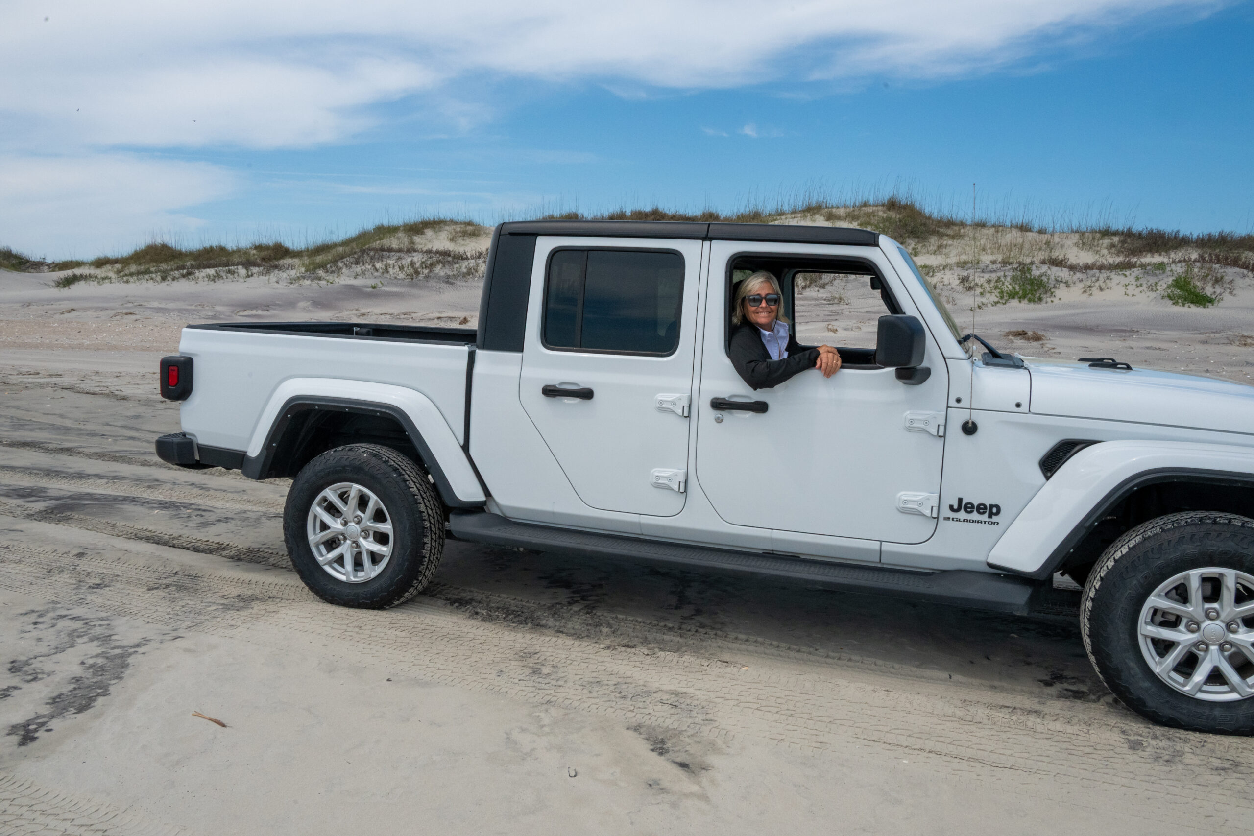
The next morning, April 11th, George decided that the wind and waves were indeed in our favor to cross Pamlico Sound to visit Ocracoke Island. We left early to take advantage of the west wind. As we ventured further into Pamlico Sound, the waves increased in size, but fortunately they were on our stern, so even though Assisted Living wallows a in following seas, it was not uncomfortable. We took the main channel into Ocracoke, which is only 3’ deep at low tide, but of course, we had timed our arrival to overcome that at high tide. Our plan was to dock at the National Park Dock, but it wasn’t very well marked. We floated around a bit in the harbor until we finally saw a small, brown National Parks emblem next to the busy ferry docks. There were no other boats docked there, so we wound our way around some inconveniently placed pilings and tied up lay along style to the fixed pier. All the National Parks we have recently visited have gone full on high tech, and Ocracoke was no exception. We wrangled with the QR code and figured out how to pay for dockage. We had located a four-wheel jeep agency just down the road that rented jeep that were permitted to drive on the beach. We couldn’t miss this unique opportunity, so splurged on a full day jeep rental. After a short orientation ride with the agency owner who explained how and where we could access the beaches, we were off. The experience turned out to be one of the highlights of our trip.

We first drove all the way to the extreme north end of the island, and the further north we went the narrower the island became, to the point where there was barely any sand between the highway and the waves crashing onshore. Recent hurricanes have severely eroded the thin strip of sand along which the highway runs, and Mother Nature continues to take more every day. The government had piled huge rubber like sandbags all along the ocean side of the road in a mostly futile attempt to arrest the damage.

After heading back south on the highway we ventured onto the beach at the first access point. What a trip! The sand was soft, so the jeep wallowed and fishtailed even though we drove quite slowly. The shoreline was full of trucks and jeep-trucks (like our rental) that were parked stern to the breaking waves, and families and fisherman were enjoying fishing and picnics laid out on truck tailgates. The second beach access point was for pedestrians, so we parked in the lot and walked down to the beach. Chris was fascinated with the different shells, even the oyster shells which were so much larger and more colorful than we find at home. Further down the beach, we found another vehicular access point and gave beach driving another go. This time the beach was chock full of “sand moguls” and after about ten or fifteen minutes of getting beaten to death, we headed back to the road. We drove towards town and found a place to get a quick bite to eat, then drove over to the iconic Ocracoke Lighthouse. Due to ongoing repairs, we were unable to climb the lighthouse, but it was still fun to see and photograph it.

We had noticed a gourmet store and wine bar tucked into a residential neighborhood and thought it might be fun to pick up some prepared goodies, so we headed over to Zillies Island Pantry. Along the way, we admired quaint beach cottages with beach bicycles stacked out front (like the perfect vacation spot from yesteryear). Around the corner from Zillies we came upon the historic British Cemetery that included the graves of British soldiers killed during World War II when their naval ship was torpedoed by a German U-boat off the coast of Beaufort. The Zillies Island Pantry was full of locals enjoying glasses of wine on the store’s oversized front porch. It was a nice stop.
On the way to return the jeep, we detoured to find a local attraction, the Doll Tree, which was a bizarre collection of dolls and doll parts hung like Christmas ornaments from a large tree in the front yard of someone’s house. I am sure the neighbors were thrilled about the ‘artistic’ display and the tourist traffic. We returned to the boat with takeout food for dinner and for a little bit of Netflix to cleanse from our minds the disturbing image of the hanging dolls.


The next morning, we took our time getting off the dock because the wind was predicted to calm later and to switch directions to one more favorable for our trip across Pamlico Sound (ha! – liar, liar, pants on fire). We exited Ocracoke by way of the ferry channel because one would think it would be plenty deep. As we are headed out the ferry channel, we saw a ferry about to head in coming our direction. George sped up to try to get out of the channel so as to not be squeezed by the incoming ferry, but instead, the ferry held outside the channel and waited for us to exit( God bless that uncharacteristically kind commercial captain). It was a bigger blessing than we initially appreciated; the channel was not nearly as deep as shown on our charts, and the ATONS (aids to navigation) were not in the locations shown on our three different sources (Navionics, Aqua Map, and Garmin Charts). It got a little hairy there for a minute, and we even saw some negative depth readings, but since we did not run aground, those readings were likely an indication of our props being so close to ground that they stirred up enough debris to confuse the depth sounder.
Once we were in the Sound, our day went downhill fast (with Chris wondering, how was that even possible since we just missed being run over by a ferry and running aground). The wind had not calmed or switched as predicted and we found ourselves in shallows off of Howard Reef with two converging currents making the water crazy, then moved on to Pamlico Sound with winds nearing 20 knots and steep waves of short duration at right angles to the boat. We violently rocked from side to side, so much so that the drawers in the salon would bang open on one roll, then slam shut on the opposing roll. Chris had to crouch in the salon floor with her back bracing the drawers. Since our fancy gyro was still not working, we had no way to stabilize our ride except to change course. George altered course for Bay River instead of going directly from Pamlico Sound to the Pamlico River. We retraced our wake and went thirty miles before we could head north again in the ICW. Upon finally reaching the Pamlico River, the wind was directly in our face, so we took those four miles very slowly because of all the water rushing over the bow of the boat as we bashed headlong into big waves (but still ten times better than rolling from side to side). We finally turned north at Pungo River where we were protected by land and could make reasonable progress.
Our fuel tanks were down just below 50%, so we decided to stop for a little fuel to hold us over until we could reach a place further north we had found advertising a reasonable price for diesel (of course, “reasonable” being relative). At our quick fuel stop in Belhaven, NC, we were greeted on the dock by CeCe and Brad from House Is A (a Ranger Tug 29) whom we had conversed with over the VHF when we were wandering around Southport, NC trying to find a good spot to anchor or dock. When we spoke to them in Southport it was the very first day of their Loop, so they hadn’t known any more about Southport anchorages than we did. They were staying in Belhaven for a few days, but we hope that we will cross paths with them again as we both travel north. After Belhaven, we tried to anchor in Scranton Creek, but the bottom was full of muck, and the anchor wouldn’t hold in the 18 knot winds. As the sun was setting, we backtracked slightly to Deep Point, an indention in the Pongo River where the river’s south bank offered some slight protection from the wind. Even though we were only in about 6’ of water, we put out over 100’ of chain to account for the strong wind and our recent problems with holding. We had dragged anchor more in the past month than we had in our entire thirty-five prior years of boating. We were ready to close the book on North Carolina.


George put together a video of some highlights of our time in North Carolina. Next stop, Great Bridge, Virginia.